|
Alakanuk
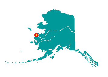 Alakanuk
is located at the east entrance of Alakanuk Pass, the major southern
channel of the Yukon River, 15 miles from the Bering Sea. It is part of
the Yukon Delta National Wildlife Refuge. It lies 8 miles southwest of
Emmonak, approximately 162 air miles northwest of Bethel. It is the
longest village on the lower Yukon - the development stretches over a 3
mile area along the Pass. Approximately 25 homes along the bank are
being threatened by erosion. It lies at approximately 62° 41' N
Latitude, 164° 37' W Longitude (Sec. 14, T030N, R082W, Seward Meridian).
The community is located in the Bethel Recording District. The area
encompasses 35 sq. miles of land and 6 sq. miles of water. Alakanuk
is located at the east entrance of Alakanuk Pass, the major southern
channel of the Yukon River, 15 miles from the Bering Sea. It is part of
the Yukon Delta National Wildlife Refuge. It lies 8 miles southwest of
Emmonak, approximately 162 air miles northwest of Bethel. It is the
longest village on the lower Yukon - the development stretches over a 3
mile area along the Pass. Approximately 25 homes along the bank are
being threatened by erosion. It lies at approximately 62° 41' N
Latitude, 164° 37' W Longitude (Sec. 14, T030N, R082W, Seward Meridian).
The community is located in the Bethel Recording District. The area
encompasses 35 sq. miles of land and 6 sq. miles of water.
Alakanuk is a Yup'ik word meaning
"wrong way," aptly applied to a village on this maze of watercourses.
The village was first reported by G.R. Putnam of the U.S. Coast &
Geodetic Survey in 1899. It was originally settled by a Yup'ik shaman
named Anguksuar and his family. A Catholic mission school was built near
the village. A post office was established in 1946. In 1948, the school
was relocated to St. Mary's, and many families moved from the old school
site to Alakanuk. It incorporated as a second-class city in 1969.
|
